Back-to-back systems to make for messy mix of rain and snow this week
Nor'easter passes by Nova Scotia Thursday, and a low-pressure system is expected Friday

A pair of winter storms is expected to bring a messy mix of rain, wind and snow to Nova Scotia that will last into the weekend.
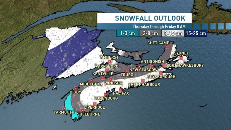
A nor'easter will just miss the province on Thursday, but snow will start to fall tonight in the southwest and is expected to quickly track north to Cape Breton by tomorrow afternoon.
The first storm won't actually pass over the Maritimes — instead moving up the coast of Maine to the St. Lawrence River valley — but that doesn't mean Nova Scotia will be spared.
Much of Nova Scotia can expect five to 15 centimetres, with the most snow falling in Cape Breton and along the Atlantic coastline to Liverpool, according to CBC meteorologist Kalin Mitchell.

"Give yourself time and space on the roads for the Thursday morning commute, as for much of the west of Nova Scotia, they will be snowy and slippery," said Mitchell.
Winds will increase to between 30 and 50 km/h, with gusts up to 90 km/h on Thursday before diminishing into the evening.
There are wind warnings in place for Queens County and Shelburne County, with gusts up to 90 km/h overnight Wednesday night and Thursday morning.
There's a Les Suetes wind warning in place for Inverness County, with gusts up to 100 km/h forecast to develop Thursday evening and then diminish early Friday morning.
In western and central Nova Scotia, the snow with change over to rain Thursday, but will persist into the evening in the eastern parts of the province.
New Brunswick will get the brunt of the storm with 15-25 centimetres expected in much of the province, and up to 15 centimetres expected in P.E.I.
2nd storm starts Friday
The second storm of the week will develop off the Atlantic coast on Friday morning. As it moves back over land, it will bring with it the possibility of significant snowfall.
But it's still too early to say how much snow will fall or where, said Mitchell.
"Currently the area that looks under the biggest risk to see significant accumulations of 15-plus centimetres from this second weather system is Cape Breton and eastern areas of the mainland," said Mitchell.
Depending how far the storm moves into the Maritimes, it's possible other areas of Nova Scotia could also see accumulating snow on Friday night and Saturday.
With files from Kalin Mitchell