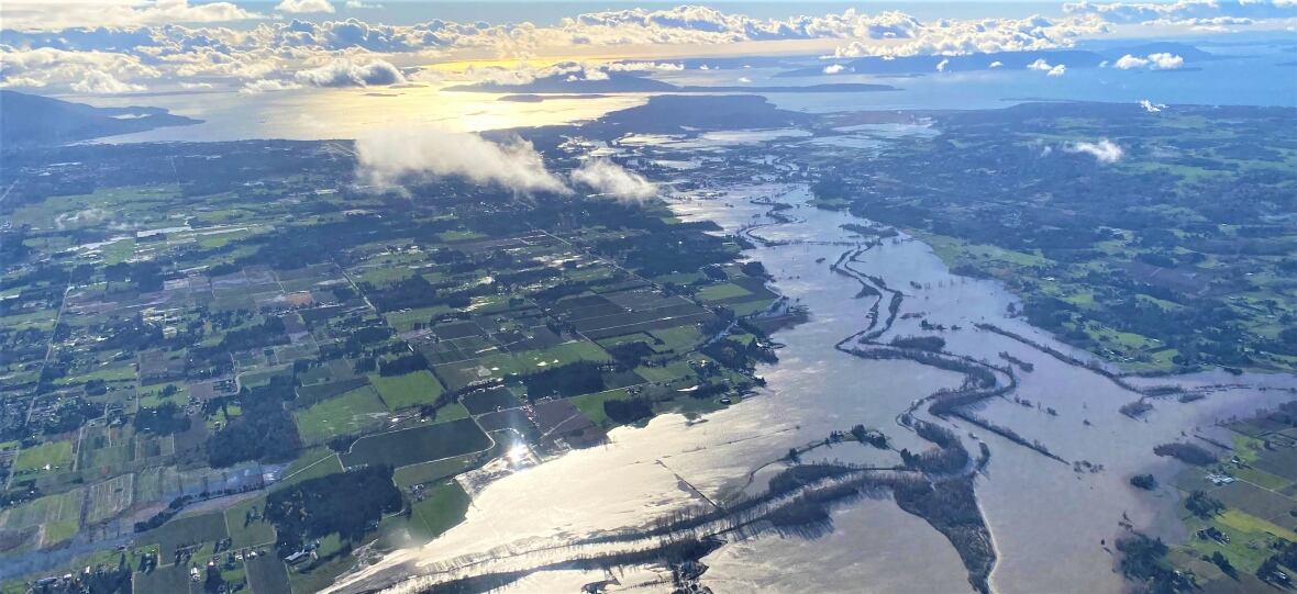
Weekend rain drenches southwest B.C., prompting flood warnings, evacuations
The province has closed Highway 1 near Abbotsford, B.C.
THE LATEST:
- Another possible record-setting storm is set to arrive Tuesday.
- A flood warning was issued for the Coquihalla River, Sumas River, Tulameen River, Coldwater River, and Lower Nicola River. For all flood advisories see here.
- On Sunday, evacuation orders were issued for properties close to waterways around Abbotsford and in the Thompson-Nicola Regional District. For more on evacuation alerts and orders see here.
- Highway 1 between Chilliwack and Hope was closed to traffic at 5 p.m. PT on Sunday. For a full list of closures, see here.
- The District of Hope declared a state of local emergency.
- The University of the Fraser Valley cancelled all in-person classes for next week.
- The Abbotsford School District said Robert Bateman Secondary and WJ Mouat Secondary secondary schools would offer virtual learning for the week, while all other district schools would meet in person.
More rain drenched southwestern B.C. on Sunday causing already swollen waterways to overflow and forcing more people to evacuate their properties.
In hard hit Abbotsford, southeast of Metro Vancouver, officials were advised that waters had risen above a dike on the Nooksack River in Washington State, and was pooling between the river and a nearby road.
Abbotsford Mayor Henry Braun expected the water to eventually reach Abbotsford and that existing sandbag walls were not enough to mitigate flooding.
Rising waters prompted the province to close the TransCanada Highway (Highway 1) between Abbotsford and Chilliwack at 5 p.m. PT Sunday night.
New evacuation orders were issued for properties in the Huntingdon Village area of Abbotsford. Later Sunday evening, more evacuation orders were issued for seven homes on the city's Whatcom Road, while other properties along Sandringham Drive were put on an evacuation alert following a mudslide in the area.

Evacuation orders were also issued for homes along Chilliwack Lake Road, east of Abbotsford and also for Othello Road, which runs along the Coquihalla River.
Meanwhile, the RCMP went door-to-door in the Spius Creek area west of Merritt to tell people to evacuate their homes.
On Sunday, B.C.'s River Forecast Centre issued a flood warning for the Coquihalla River and the Sumas River, which include Sumas Prairie and the surrounding area.
It also upgraded flood watches to warnings for the Tulameen River, Coldwater River, and Lower Nicola River.
A flood warning means river levels have exceeded banks and that flooding in adjacent areas will occur.
WATCH | Rain, snow compound flood risks in Abbotsford, B.C.:
The Fraser Valley region has been under a flood watch since Friday, as has most of southwest B.C., including regions of Vancouver Island.
High streamflow advisories were also issued by the River Forecast Centre for the Upper Columbia and East Kootenay regions in the Interior.
On Sunday evening, the District of Hope, about 155 kilometres east of Vancouver, declared a state of local emergency and later placed homes on Riverview Drive on an evacuation alert.
Evacuation alerts mean residents must be ready to leave their homes at a moment's notice. Evacuation orders mean residents should leave immediately.

The downpour has also led to increased danger on several of B.C.'s already damaged highways.
On Sunday at 5 p.m. the province closed Highway 1 between Abbotsford and Chilliwack due to the impact of rains over the weekend. Officials did not say when the section of roadway would reopen.
Later, the province tweeted a picture of workers, which in included members of the Canadian Armed Forces putting in place barriers along Highway 1 to hold back waters overflowing from the Sumas River.
Another look at the tiger dam we're setting up tonight on <a href="https://twitter.com/hashtag/BChwy1?src=hash&ref_src=twsrc%5Etfw">#BChwy1</a> in <a href="https://twitter.com/hashtag/Abbotsford?src=hash&ref_src=twsrc%5Etfw">#Abbotsford</a> to hold back Sumas River floodwaters. Working in collaboration with the Canadian military, Shxwowhamel Ventures, <a href="https://twitter.com/AbbyPoliceDept?ref_src=twsrc%5Etfw">@AbbyPoliceDept</a> <a href="https://twitter.com/BCRCMP?ref_src=twsrc%5Etfw">@BCRCMP</a> to create a barrier that works to address the <a href="https://twitter.com/hashtag/BCflood?src=hash&ref_src=twsrc%5Etfw">#BCflood</a>. <a href="https://t.co/pG3e2EUTJV">pic.twitter.com/pG3e2EUTJV</a>
—@TranBCTransportation Minister Rob Fleming asked residents on Sunday to stay off roads in affected areas.
"If you don't need to be driving, please do not take your vehicle out on the roads at this time."
Precautionary road closures put in place Saturday for Highway 3 from Hope to Princeton, Highway 1 in the Fraser Canyon, Highway 1 from Popkum to Hope and Highway 99 from Lillooet to Pemberton remained in place.
WATCH | Head of B.C. beef and dairy farm services company calls for better cross-border response to flooding:
Meteorologists say another storm is expected to make landfall Monday night and into early Tuesday.
Public Safety Minister Mike Farnworth said the province is prepared to use the Alert Ready system to get information out to residents in southwestern B.C., who could be affected by flooding.
Anyone placed under an evacuation order should leave the area immediately.
To find an evacuation centre close to you, visit the Emergency Management B.C. website.
Evacuees are encouraged to register with Emergency Support Services online, whether or not they access services at an evacuation centre.
Road conditions can be checked at DriveBC.
With files from Gurpreet Kambo, Olivia Stefanovich and CBC News Network

